Introduction
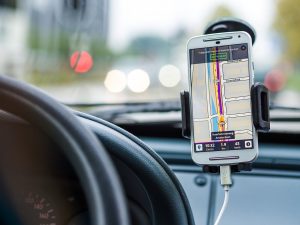
Welcome to the world of augmented reality (AR) and GPS navigation! Gone are the days of relying solely on maps or written directions to navigate unfamiliar territory. Thanks to the advancements in technology, we now have GPS apps like Waze and Google Maps that seamlessly integrate augmented reality into our navigation experience.
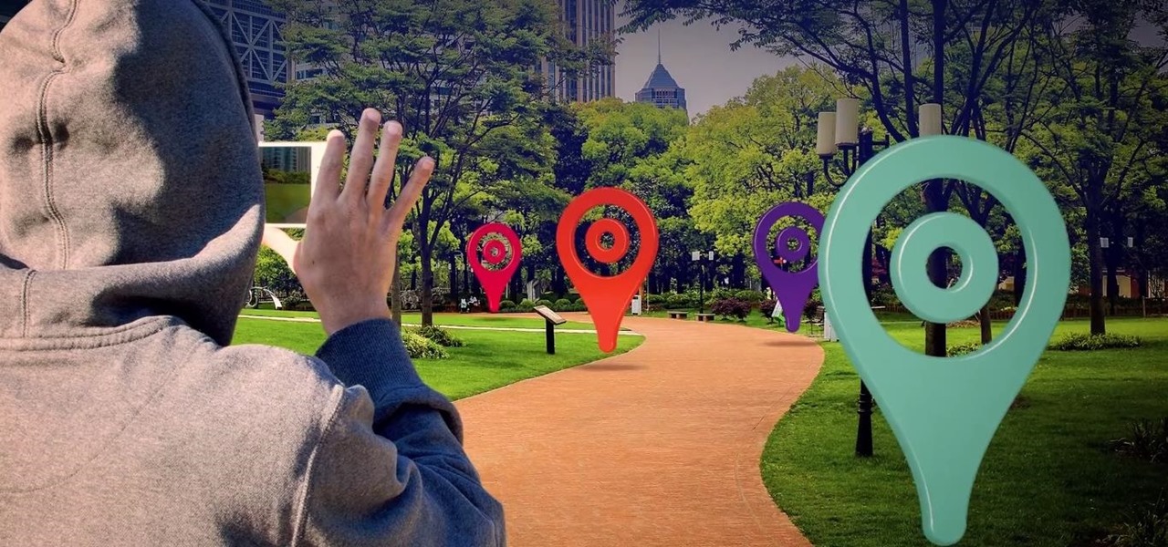
But what exactly is augmented reality? In simple terms, it is a technology that superimposes computer-generated images or information onto the real world, enhancing our perception and interaction with our surroundings.
With the rise in popularity of smartphones and GPS apps, it’s no surprise that AR has found its way into navigation tools. GPS apps have revolutionized the way we navigate, providing real-time directions, route suggestions, and traffic updates. And now, with the integration of augmented reality, the navigation experience is taken to a whole new level.
In this article, we will delve into how GPS apps like Waze and Google Maps utilize augmented reality, the benefits of using AR in navigation, and some examples of the augmented reality features found in these apps. We will also explore how augmented reality enhances the overall navigation experience and discuss potential future developments in this exciting field.
So, buckle up and get ready to embark on an exciting journey into the world of augmented reality navigation!
What is Augmented Reality?
Augmented reality (AR) is a technology that overlays virtual elements on top of the real world, enhancing our perception and interaction with our surroundings. Unlike virtual reality, which creates a completely immersive experience in a virtual environment, augmented reality blends the virtual with the real.
AR applications use a combination of sensors, cameras, and software to detect the user’s environment and superimpose virtual objects or information onto it in real time. This can be done through smartphones, tablets, or dedicated AR devices like smart glasses.
The goal of augmented reality is to enhance our understanding of the physical world by providing additional context and information. It can bring static objects to life, provide interactive experiences, and enable us to visualize data in new and meaningful ways.
Augmented reality has found its way into various industries, including gaming, education, advertising, and now navigation. By using AR in navigation apps like Waze and Google Maps, users can get real-time information about their surroundings, such as road conditions, directions, and points of interest.
AR technology has come a long way since its inception, with improvements in computer vision, graphics processing, and device capabilities. This has allowed for more accurate and seamless integration of virtual elements into the real world, making augmented reality a powerful tool for enhancing our everyday experiences.
Whether it’s overlaying turn-by-turn directions on a smartphone screen or displaying AR markers to guide users in real-time, augmented reality has opened up endless possibilities for navigation and beyond.
GPS Apps and Augmented Reality
GPS apps have become an indispensable tool for modern-day navigation. They provide us with accurate directions, real-time traffic updates, and alternative routes to help us reach our destinations efficiently. However, traditional GPS apps primarily rely on visual maps and audio instructions to guide users.
Augmented reality has brought a new dimension to GPS apps by incorporating virtual elements into the real-world view. With the use of cameras and sensors on smartphones, these apps can analyze the surroundings and overlay relevant information directly onto the screen in real-time.
This integration of augmented reality in GPS apps has greatly enhanced the user experience. Users can now see the road ahead with virtual signages, directions, and real-time navigation indicators superimposed on the live camera feed. This visual representation not only helps users understand their surroundings better but also reduces the chances of missing vital information while driving or walking.
One of the main advantages of using augmented reality in GPS apps is its ability to provide a more intuitive navigation experience. Traditional GPS apps may require users to constantly read and interpret the map, which can be distracting and time-consuming. With augmented reality, the virtual elements are seamlessly integrated into the real-world view, making it easier for users to understand and follow the directions without losing focus on the road.
In addition to visual enhancements, GPS apps with augmented reality can also utilize audio cues and haptic feedback to further enhance the navigation experience. For example, the app can use voice commands to provide turn-by-turn instructions while displaying virtual arrows on the screen. This multimodal approach ensures that users receive information through multiple channels, increasing their situational awareness and reducing the chances of making wrong turns.
Furthermore, augmented reality in GPS apps allows users to explore points of interest along their route more conveniently. Users can simply point their phones at a location to see information such as ratings, reviews, and opening hours of nearby businesses or landmarks. This feature not only helps users make more informed decisions but also encourages exploration and discovery while navigating.
GPS apps with augmented reality are continuously evolving to provide more sophisticated features and a seamless user experience. They are transforming the way we navigate by bridging the gap between the virtual and real world, making our journeys safer and more engaging.
How GPS Apps Utilize Augmented Reality
GPS apps like Waze and Google Maps have embraced augmented reality technology to provide users with a more immersive and intuitive navigation experience. These apps leverage various features and functionalities to effectively utilize augmented reality in their interfaces.
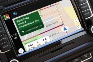
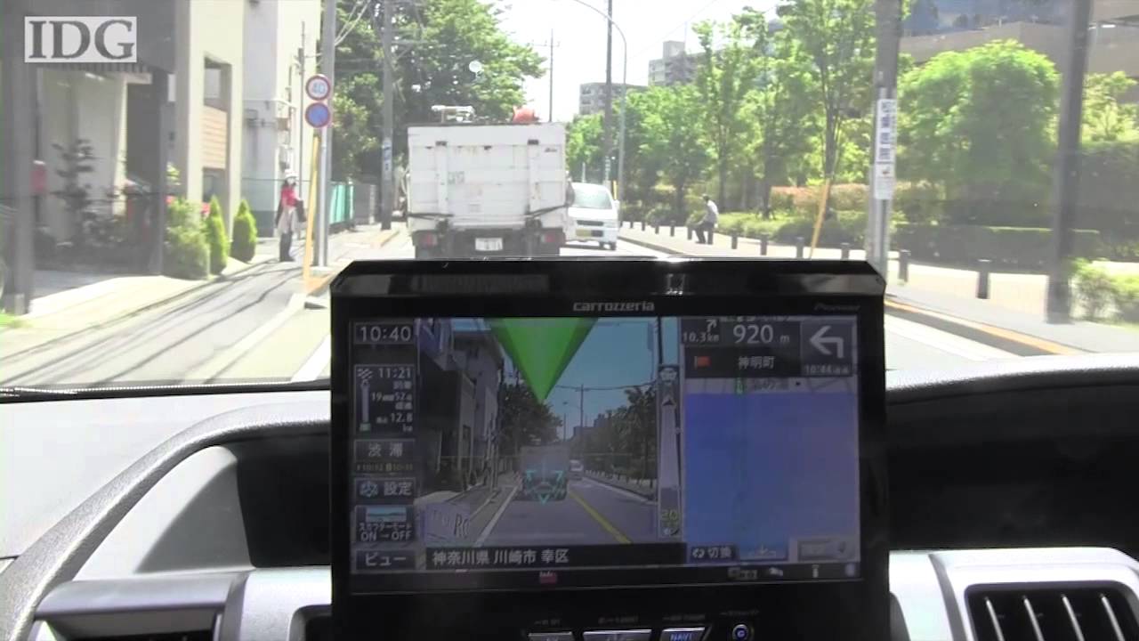
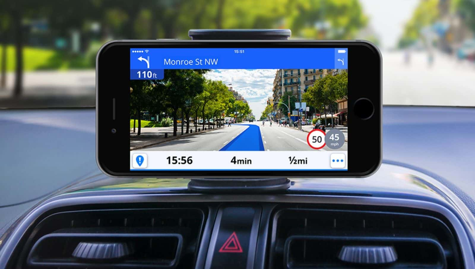
Camera Integration: One of the key ways GPS apps utilize augmented reality is by integrating the smartphone’s camera. By accessing the camera feed, these apps analyze the user’s surroundings in real-time and overlay virtual elements onto the screen. This allows users to see real-time information about their route, including directions, street names, and points of interest, directly superimposed on the live camera feed.
Visual Markers: GPS apps often utilize visual markers to guide users along their route. These markers can come in the form of virtual signages or arrows displayed on the screen that indicate when and where to turn. Augmented reality enables these markers to be overlaid onto the real-world view, making it easier for users to understand and follow the directions.
Street View: Another way GPS apps utilize augmented reality is through the integration of street view imagery. By combining the camera feed with street view data, these apps can provide users with a more realistic and immersive navigation experience. Users can see their surroundings in a 360-degree view, allowing for better orientation and familiarity with the environment.
Real-Time Data Overlay: Augmented reality in GPS apps also enables the overlay of real-time data onto the user’s view. This includes traffic information, road closures, construction zones, and other relevant updates. By presenting this information visually in real-time, users can make informed decisions about their route and avoid potential delays or obstacles.
Enhanced POI Exploration: Points of interest (POI) are a crucial aspect of GPS navigation apps. Augmented reality takes POI exploration to the next level by allowing users to view information about nearby businesses or landmarks simply by pointing their camera at them. Users can see ratings, reviews, opening hours, and other relevant details overlaid onto the real-world view, making it easier to find and select destinations based on their preferences.
Multi-Modal Integration: In addition to visual cues, GPS apps that utilize augmented reality also incorporate audio and haptic feedback. Users can receive voice instructions, alerts, and notifications, ensuring they receive guidance through multiple sensory channels. This multi-modal integration enhances the overall navigation experience by providing users with a comprehensive and engaging interface.
Overall, GPS apps make use of augmented reality technology to transform the traditional navigation experience. By seamlessly integrating virtual elements onto the real-world view, these apps provide users with a more intuitive, immersive, and informative way to navigate their surroundings.
Benefits of Using Augmented Reality in GPS Apps
The integration of augmented reality (AR) in GPS apps like Waze and Google Maps offers a range of benefits that enhance the overall navigation experience for users. Let’s explore some of the key advantages of using augmented reality in GPS apps:
1. Enhanced Visualization: Augmented reality provides users with a visual representation of their route and surroundings in real-time. By overlaying virtual elements onto the live camera feed, users can better understand their location, upcoming turns, and points of interest. This visual integration improves situational awareness and reduces the chances of missing critical information while navigating.
2. Intuitive Navigation: Augmented reality eliminates the need for users to constantly refer to maps or written directions. With virtual signages, arrows, and real-time navigation indicators superimposed on the real-world view, users can easily follow the directions without diverting their attention away from the road. This intuitive navigation experience simplifies the process of reaching a destination and reduces the risk of getting lost.
3. Real-Time Updates: GPS apps with augmented reality provide users with real-time updates on traffic conditions, road closures, and construction zones. By overlaying this information onto the camera view, users can make informed decisions about their route and find alternative paths to avoid delays. Real-time updates ensure that users have the most up-to-date information for a smooth and efficient navigation experience.
4. Interactive Points of Interest (POI): Augmented reality enhances the exploration of points of interest along a user’s route. By utilizing the smartphone’s camera, users can easily discover information about nearby businesses, landmarks, and attractions. This interactive feature allows users to access details such as ratings, reviews, and opening hours directly overlaid onto the real-world view, making it convenient to make informed decisions while on the move.
5. Multimodal Feedback: Augmented reality in GPS apps goes beyond visuals by incorporating audio and haptic feedback. Users can receive voice instructions, alerts, and notifications, ensuring that they are aware of upcoming turns or changes in their route. This multimodal integration enhances the user experience, providing guidance through multiple sensory channels and reducing the reliance on visual cues alone.
6. Safety and Convenience: By presenting the navigation information in an augmented reality format, users can keep their eyes on the road while still being aware of their surroundings. This improves safety by minimizing distractions and allowing users to focus on driving. Additionally, the convenience of seeing important information directly on the screen without the need to switch between apps or devices makes augmented reality a valuable tool for seamless and hassle-free navigation.
Overall, utilizing augmented reality in GPS apps brings a host of benefits for users. With enhanced visualization, intuitive navigation, real-time updates, interactive POI exploration, multimodal feedback, and increased safety and convenience, augmented reality elevates the navigation experience and simplifies the process of reaching our destinations.
Examples of Augmented Reality Features in GPS Apps
The integration of augmented reality (AR) in GPS apps has resulted in the development of various innovative features that enhance the navigation experience. Let’s explore some examples of how augmented reality is utilized in popular GPS apps like Waze and Google Maps:
1. Virtual Road Signs: Augmented reality enables GPS apps to overlay virtual road signs onto the real-world view. These signs provide users with important information such as street names, upcoming turns, and distance to the next exit. By superimposing this information directly onto the live camera feed, users can quickly and easily understand their surroundings and make informed decisions while navigating.
2. Lane Guidance: Augmented reality in GPS apps can offer lane guidance features. When approaching complex intersections or highway interchanges, virtual arrows and indicators can be displayed on the screen, directing users to the appropriate lane for their desired route. This feature ensures that users stay on the right path and reduces the likelihood of missing turns or making sudden lane changes.
3. Destination Markers: GPS apps with augmented reality can display virtual destination markers on the screen, making it easier for users to locate their destination without relying solely on address information. These markers can be customized icons or labels that guide users towards their desired location. This feature simplifies the process of finding specific buildings, businesses, or landmarks in a crowded area.
4. Real-Time Traffic Updates: Augmented reality allows GPS apps to overlay real-time traffic updates onto the user’s camera view. Users can view traffic flow, congestion, and incidents directly on the screen. This information helps users make informed decisions about their route, enabling them to choose alternatives that avoid heavy traffic or roadblocks.
5. Point of Interest (POI) Information: Augmented reality enhances the exploration of points of interest. By utilizing the smartphone’s camera, GPS apps can display virtual information about nearby businesses, landmarks, restaurants, and attractions. Users can view ratings, reviews, opening hours, and other relevant details overlaid onto the real-world view, making it convenient to discover and choose POIs while on the go.
6. Street View Integration: Augmented reality feature in GPS apps can integrate with street view imagery. This allows users to see real-time camera images alongside street view images, providing them with a more realistic and immersive navigation experience. Users can virtually explore their surroundings and gain a better understanding of their location and nearby landmarks.
These are just a few examples of how augmented reality features have been implemented in GPS apps. The continuous development and advancements in AR technology promise exciting possibilities for further enhancing the navigation experience, providing users with even more immersive and informative tools to navigate their way to their destinations.
How Augmented Reality Enhances Navigation Experience
Augmented reality (AR) has revolutionized the way we navigate by enhancing the overall navigation experience. Here are some key ways in which augmented reality enhances the navigation experience in GPS apps:
1. Enhanced Spatial Awareness: Augmented reality provides users with a visual representation of their surroundings in real-time. By overlaying virtual elements onto the live camera view, users can better understand their location, upcoming turns, and nearby landmarks. This enhanced spatial awareness allows for better orientation and a clearer understanding of the environment, ultimately leading to more confident and accurate navigation.
2. Easy Interpretation of Directions: Traditional directions on a map can sometimes be challenging to interpret, especially in complex or unfamiliar areas. Augmented reality simplifies the process by superimposing virtual signages, arrows, and symbols onto the real-world view. Users can easily understand and follow these visual cues, eliminating the need to constantly refer to maps or written instructions.
3. Real-Time Updates at a Glance: Augmented reality in GPS apps enables real-time updates to be displayed directly on the screen. Users can quickly see traffic conditions, road closures, and other relevant information overlaid onto the camera view. These visual updates allow for immediate awareness of any obstacles or delays, enabling users to make efficient decisions about their route and find alternative paths if necessary.
4. Seamless Integration of Points of Interest: Augmented reality simplifies the exploration of points of interest (POI) along a user’s route. By utilizing the smartphone’s camera, GPS apps can superimpose virtual information about nearby businesses, landmarks, and attractions onto the real-world view. Users can easily discover details such as ratings, reviews, and opening hours, making it convenient to select POIs that suit their preferences while on the move.
5. Visual and Auditory Multimodal Guidance: Augmented reality in GPS apps goes beyond visual cues by incorporating audio and haptic feedback. Users can receive voice instructions, alerts, and notifications, ensuring they are aware of upcoming turns or changes in their route. This multimodal integration enhances the overall navigation experience, providing guidance through multiple sensory channels and reducing reliance on visual cues alone.
6. Interactive and Engaging Navigation Experience: Augmented reality makes the navigation experience more immersive and engaging. Users can visualize their route overlaid onto the real-world view, creating a seamless blend of the virtual and physical environments. This interactive experience encourages exploration and discovery, making the journey more enjoyable and inspiring users to venture into new areas.
Overall, augmented reality enhances the navigation experience by providing an intuitive and informative interface. It improves spatial awareness, simplifies directions, offers real-time updates, seamlessly integrates points of interest, provides multimodal guidance, and creates an interactive and engaging navigation experience. With augmented reality, GPS apps go beyond static maps and transform navigation into an immersive and dynamic journey.
Potential Future Developments in Augmented Reality for GPS Apps
The integration of augmented reality (AR) in GPS apps has already transformed the way we navigate, but the technology continues to evolve, paving the way for exciting future developments. Here are some potential advancements that we may see in augmented reality for GPS apps:
1. Improved Object Recognition: Future developments in augmented reality can lead to more advanced object recognition capabilities. GPS apps could become even more intelligent in identifying and displaying relevant information about objects such as street signs, traffic lights, or nearby landmarks. This would provide users with a more detailed and informative navigation experience.
2. 3D Mapping and Visualization: As AR technology advances, we may see GPS apps incorporating more sophisticated 3D mapping and visualization techniques. This would enable users to have a more immersive and realistic view of their surroundings, increasing spatial awareness and making navigation more intuitive. Users could experience detailed 3D representations of buildings, landmarks, and even terrain, providing a more accurate and immersive navigation experience.
3. Augmented Reality Headsets: Currently, most GPS apps use smartphones as the primary device for augmented reality navigation. However, the development of augmented reality headsets could bring about a shift in how GPS apps are accessed and utilized. Dedicated AR headsets could provide users with a more seamless and hands-free navigation experience, allowing them to receive real-time information without having to hold or interact with a smartphone.
4. Contextual and Personalized Information: In the future, augmented reality in GPS apps could become more contextually aware and personalized. By analyzing user preferences, past navigation patterns, and real-time data, GPS apps could provide more customized and relevant information. For example, users may receive personalized alerts and suggestions based on their interests or preferred routes, enhancing the navigation experience and making it more tailored to individual needs.
5. Enhanced Collaborative Navigation: Augmented reality in GPS apps could facilitate more collaborative navigation experiences. Users could share real-time information, such as road conditions, accidents, or traffic congestion, with other users in their vicinity. This crowd-sourced information would be displayed in augmented reality, providing a more comprehensive and up-to-date view of the road conditions. Collaborative navigation would create a sense of community among users and foster a collective effort to improve the overall navigation experience.
6. Integration with Internet of Things (IoT): Augmented reality in GPS apps can potentially integrate with IoT devices, expanding the range of information available to users. For example, smart city infrastructure, such as connected traffic lights and parking systems, could provide real-time information to GPS apps. This integration would enable users to receive updates and suggestions based on the available data, further optimizing their navigation routes and enhancing the overall efficiency of the navigation experience.
As technology continues to evolve, augmented reality in GPS apps will likely undergo exciting advancements. These developments may include improved object recognition, enhanced 3D mapping, the emergence of dedicated AR headsets, personalized and contextual information, collaborative navigation, and integration with IoT devices. These advancements will undoubtedly provide users with more immersive, intuitive, and efficient navigation experiences in the future.
Conclusion
Augmented reality (AR) has transformed the navigation experience in GPS apps like Waze and Google Maps, bringing a new dimension to how we navigate our surroundings. By seamlessly integrating virtual elements onto the real-world view, augmented reality enhances spatial awareness, simplifies directions, provides real-time updates, and creates an immersive and engaging navigation experience.
The benefits of using augmented reality in GPS apps are manifold. It offers enhanced visualization, intuitive navigation, real-time updates, simplified exploration of points of interest, multimodal guidance, and increased safety and convenience.
Looking ahead, there are exciting potential developments on the horizon for augmented reality in GPS apps. These include improved object recognition, advanced 3D mapping, the emergence of dedicated AR headsets, contextual and personalized information, collaborative navigation, and integration with IoT devices. These developments will further enhance the navigation experience, making it more immersive, intuitive, and efficient.
As technology evolves, augmented reality will continue to revolutionize the way we navigate, bridging the gap between the virtual and physical worlds. From providing real-time directions to seamlessly integrating with smart city infrastructure, augmented reality holds much promise for the future of GPS navigation.
So, whether you are using Waze, Google Maps, or any other GPS app with augmented reality, get ready to embark on a more engaging and immersive navigation journey. With augmented reality as our guide, the way we navigate the world will never be the same again.