Everyone has probably heard of Google Maps by now. And anyone who has bothered to look into the app probably knows that it has a long list of unexpected and delightful features. Find out more about these little gems that the app has to offer. If you’re looking for a comparison of Waze VS Google Maps, we have an article just for you.
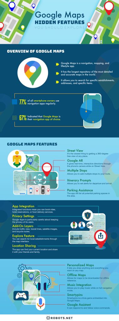
Overview Of Google Maps

Google Maps is a navigation, mapping, and lifestyle app. It has the largest repository of the most detailed and accurate maps in the world. It’s a little wonder why it is the most popular and most downloaded navigation app in the world. The app allows you to view maps in three ways: flat default maps, visual representations of any area, the satellite view that shows actual, aerial views of any area, and the terrain view that features 3D topographic images of any area.
The maps are multi-purpose. They can be used for almost any activity that requires mapping and navigation. Moreover, the app is loaded with hundreds of features. The most notable and popular of all is the GPS navigation. This allows the app to interact with the user. Also, it provides real-time information and directions to and from any place in the world. Furthermore, the app can provide directions to commuters, bikers, and pedestrians.
Additionally, the app is also advertised as a lifestyle app, meaning it functions as a reference for commercial purposes. The explorer function is a comprehensive resource. It allows you to search for specific establishments, addresses, and specific items. It can even tell you can buy these items. The app is also integrated with other apps like Instagram, Lyft, and Booking.com. This makes it easy to acquire particular services without having to switch apps.
With the sheer amount of detail on its maps and the versatility and functionality of the app, it’s clear that Google Maps is an unparalleled player in the field of navigation apps.
If you’re looking to use Google Maps while driving, you’ll need to secure your phone and keep your eyes on the road. Check out this cup holder phone mount on Amazon today and keep your phone secure while your eyes stay on the road.
Google Apps Is Leading The Navigation Field

The Manifest researched the most favored navigation apps in the world. The study revealed that over three-fourths (77%) of all smartphone owners use navigation apps regularly. Out of this 77%, 87% indicated that they use navigation apps to provide driving directions. Meanwhile, 67% out of the 77% indicated that Google Maps is their navigation app of choice. Google Maps has a large advantage over its major competitors Waze (12%), Apple Maps (11%), and Mapquest (8%).
The research also revealed the primary reasons why people love Google Maps. The dominant reason is that it provides clear directions (25%). A good percentage of respondents also indicated their preference for Google Maps. The main reasons include unique features (20%), user-friendly interface (20%), and the quality of directions it provides to non-drivers (17%). Fourteen percent (14%) also indicated that they had never used any other navigation application other than Google Maps.
Google Maps Features To Explore

Unless you’ve been exploring the app diligently over the years, it’s highly unlikely that you’re able to explore all features. Here, we’ve compiled a list of the Google Maps gems and all the new, subtle, and useful features that you should be aware of:
Street View
Google Maps has collected thousands of panoramic images of popular cities. It also collected photos from millions of contributors. These collectively patch up the Street View feature. It shows panoramic, high-definition photos of select streets all over the world. Also, it lets you explore landmarks and commercial establishments in the area. It’s the closest thing to getting a 360-degree free view of any place without having to be there.
Another not-so-new but a relatively hidden feature of Google Maps is Retro Street View. This feature lets you see the old photos of the area that you are currently browsing. There is a sliding option to let you choose the time scale of the photos you want to see. This feature will satisfy your intellectual and cultural curiosities. To access Street View, just tap on the compass icon, or drag your finger across the map.
Google AR
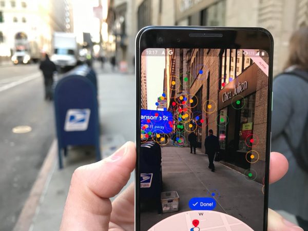
Normally directions are indicated through an animated map or representation of the area on the phone. Google AR Maps offers a new way of showing you directions. It gives real-time, interactive directions through the phone’s camera while on Street View. The feature uses Augmented Reality (AR) technology. It knows where you are and shows you exactly where you need to go through the lens of your phone camera.
To access Google AR, just type in your destination like you normally do and select the “Start AR” function. Just pan the camera towards any street on your current location and arrows, and other visual instructions will appear to guide you to your intended destination. Note: This feature is only available on Android phones that support ARCore or iPhones with ARKit Support.
Multiple Stops
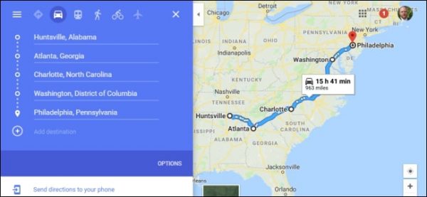
The app allows you to add multiple stops to your route. With that, you’ll have the added advantage of voice-guided turn-by-turn directions for each stop. For each added stop, the app will ask if you want to add more stops, and it will generate an ETA for the collective route. This is useful for running multiple appointments and errands. However, if you change your mind, it’s easy to delete a stop. Be reminded that Google Maps will refer to your current location as the starting point for creating route directions. To add multiple stops to your route, just click on the “Add stop” function under the “Action overflow” button and key in your next destination.
Itinerary Prompts
The app allows you to set alerts for departure and arrival, so you don’t get late for your appointments. The feature has two options: Depart At and Arrive By, although they mean the same thing. Key in your starting point and end destination first. The app will then give you an estimate of your total travel time with consideration to traffic conditions.
Given this information, you can decide the best time to leave (Depart At) or the best time to arrive (Arrive By) at your chosen destination. The app can also generate suggestions for the best time for you to leave with consideration to traffic conditions. The only downside to this is that Google Maps cannot provide an exact time estimate due to volatile traffic conditions. Traffic accidents, weather downturns, and other unforeseen changes on the road are also factors to consider.
Parking Assistance
If you’re in crowded city space and need parking space, send an SOS to Google Maps for parking. The app will list all potential parking spaces in the area. This function works for select areas only.
If you’ve already parked, you can manually save the location on your map and have Google Maps automatically save it for you. Unfortunately, you’ll need to have the location services function enabled for the latter. The app can also save the real-time GPS location of your car. However, you’ll need to pair your device through CarPlay or Bluetooth. To request the app to search for parking, just select the “Find Parking” function under the Directions toolbar.
App Integration
Google maps, like most other apps, have extensions that allow you to reach out to other apps without a need to open them. Integrated functions mean you can book rides, hotel reservations, or food delivery services right through the app. Online booking services for transportation hubs and hotels currently dominate the list. There are also links for social media apps and food delivery services. On the internet of things, apps like Lyft, Yelp, Booking.com, Instagram, Facebook, etc. are all taken to Google Maps. To look for app extensions, visit the Chrome Web Store, search for an app extension, and click “Add to Chrome.”
Privacy Settings
Google Apps is particularly careful about keeping the privacy of its users, and this is what the Incognito Mode is for. Once this mode is enabled, Google Maps will no longer track your search and location activity. There will be no traces of your on-going browsing history and location history once it’s enabled. You can also expect not to receive any notifications from the app while on incognito mode. It also cannot use your information to personalize your Google Maps Settings.
Unfortunately, GPS navigation and search recommendation functions are limited when in this mode. You can still search for a location and get directions. Unfortunately, you will not be able to access the commute, public transportation or bicycle functions in GPS mode. The app will also prohibit access to your Google maps contributions and the voice-navigation function.
Google Maps has recently added a button to clear your location history. Your location history includes all the places that your phone has tracked you at. Moreover, the app now offers an option to clear all your location history with a single click. Also, there’s an option for you to delete selected locations only if you don’t want to delete everything.
Add-On Layers
Google Maps has several add-on layers that add detail to the maps depending on what you need and/or the mode of transportation you are using. The add-on layers include traffic view, transit lines, satellite images, and bicycle routes.
Selecting the mode of transportation (bus, train, bicycle, taxi) will prompt the map to highlight routes befitting to the chosen mode of transportation. For example, if you select public transit as your mode of transportation, the map will highlight train routes and stops on your map. Furthermore, it can tell you the ETA of the next train or how crowded the train is during that particular time of day.
If you are walking with GPS mode on, you can simply key in your destination, and the map will indicate arrows to where you need to go. It even indicates your ETA to your destination. In case you get lost, there’s a special feature called Live View that lets the app recognize where you are through visual cues. All you need to do is look for the Live View button on the walking tab and pan your camera to your current path. Unfortunately, Live View is only available on Walking Mode.
Explore Feature
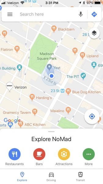
The Explorer tab is integrated with the mapping functions in Google Maps. With this, you can search for local establishments through the map interface. You’ll be able to see nearby restaurants, coffee shops, bars, etc. depending on the category entered. Moreover, the Explorer tab allows extended search results. For example, if you key in restaurants, you’ll be able to browse through menus, rankings, and user reviews within your map interface. This also allows you to contact delivery services right through the app. To search for any category, just type a search item into the search bar and tap a suggested category. You can also tap the Explore button at the bottom of the screen and scroll on “Featured lists.”
Location Sharing
If you get lost while on GPS mode, the app can find your current location and share it with your friends and family. It can also give them your ETA. If you’re taking a train or bus, it’s also possible to share your train routes with friends and family.
To share your location, you need to drop a pin on your approximate location and select the people to whom you want to send it. The recipient of your pin will also receive directions that they can follow to get to where you are. However, if you think some of the details sent by Google Maps are incorrect, you can also edit that. There’s also a “Share trip progress” button that allows you to share your ETA.
If you want to request for the location of a contact, look for the Location Sharing button and select Request. The recipient of your request can either accept or deny the request. Also, the recipient will receive a list of warnings about location sharing.
Personalized Maps
There’s a Create Map feature that lets you get creative with Google Maps. It lets you draw anything and everything you want on any map. You can add lines, shapes, markers, and even photos to your maps. By adding multiple layers to the map, you can create a very detailed map with lots of markers and features. Moreover, the app can automatically adapt the lines that you draw to match the existing routes as you drag your mouse across.
There are plenty of icons to choose from. These icons resemble the different types of icons that Google Maps usually places on the map. There are icons for food and drink, pharmacy, hospital, bar, and restaurant, among others. This feature is essential for planning trips and events with multiple stops for your friends and family to follow. You can call it an art project. Also, it is great for creating your routes for getting to work or home, biking, walking, or driving.
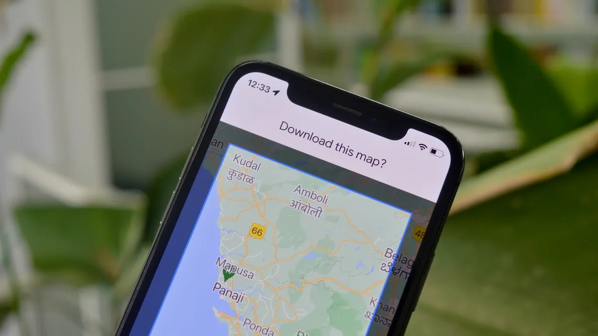
Offline Maps
The app also allows for maps to be downloaded for offline reference. However, this expires after thirty days. Once the particular area you want to download shows up on the search results, you will be asked to select the portion of the map you want to download. It’s possible to refine the details of the map by zooming in or out before downloading it. Follow the instructions and you can check your downloaded map under Offline Maps.
Once the map is downloaded to your device, it’s recommended to configure your settings. Turn on the “Wifi Only” button under Settings. Google Maps will automatically refer to your downloaded maps. This way, it will still be able to give you directions even without an internet connection.
Unfortunately, your download will expire after thirty days. At this point, the app will force you to choose between updating the map and deleting it.
Music Integration
Google Maps now allows you to play music while on full navigation mode. Just access Navigation settings enable the “Show Media playback controls.” You’ll then be asked to choose between Apple Music or Spotify. Playback controls will appear at the bottom of your Google Maps. This will let you control your music streaming as you normally do. It’s also possible to stream music and run voice navigation at the same time. You’ll only experience minor interruptions when the voice navigation speaks up, but it will resume right after.
Smartypins
Smartypins is a trivia game embedded into Google Maps. The theme of the game is world geography. The user will receive a series of trivia questions about significant locations with their historical and geographical backstories. By default, each user is given 1, 000 miles to start with. To answer each question, the player needs to drop a pin on the right location. There are six categories of trivia questions (features topics, arts and culture, science and geography, sports and games, entertainment, and history and current affairs). These appear randomly, and the player needs to maintain at least one life point to stay alive. The game ends when the player runs out of miles.
The player will receive pins corresponding to the number of correct answers. He will receive a bronze pin for five correct answers, a silver pin for ten correct answers, a gold pin for fifteen correct answers, and a diamond pin for twenty or more correct answers. Getting correct answers also adds up to your life miles.
For each mile that the answer is off from the right location, one mile is deducted from the player’s life points. The goal is to get the highest pin by answering questions correctly, and staying alive by avoiding your life miles from running out.
Google Assistant

The traditional voice commands found in older versions of Google Maps have been replaced with Google Assistant. Google Assistant is a more responsive form of artificial intelligence. It can respond to and follow voice commands. You can talk to the Google Assistant, and it can respond to basic conversations. Additionally, it can search for items on the internet, activate controls of the device, and even order food online. This upgrade almost assures completely hands-free navigation so you can focus on the road. It’s a delightful addition to the already multi-functional navigation features of the app. To activate Google Assistant, just press the Home button for a few seconds or say “Hey Google” to your device’s microphone.
Future Prospects For Google Maps

In the future, it would be great to see more apps integrated with Google Maps, and for it to have improved navigation features to accommodate multiple modes of transportation. Also, it is great to see more of the Augmented Reality visuals that they use. Maybe Google can even remove the need for human inputs and simply introduce robot counterparts to do the mapping in areas that people can’t get to. With the current rate of progress of Google Maps, there’s no doubt that greater things have yet to come.
Final Thoughts On Hidden Features

Google Maps can surpass all expectations with the myriad of features that it adds to its app. Aside from being an all-around navigation guide and lifestyle app, it’s also able to embody other tools. It’s a memorabilia collector, scheduler, historical viewbook, musical player, and gaming app-in-one. We would have never expected that a single app would be able to deliver so much, and yet it does. And the best thing about it is that it is all for free! Google Maps is, without a doubt, the best navigation and lifestyle app in the market.