Navigation apps come in handy when we travel to unfamiliar places, may it be for driving, transit, or even walking. From GuideStar, the first GPS navigation system for cars, electronic maps have already gone a long way. Today, it is safe to say Google Maps is the default choice of all travelers. But Apple is looking to challenge that, at least for Apple devices users. In 2012, the tech giant unveiled its own navigation app under the name Apple Maps.
What is Apple Maps?
We can say that Apple Maps is the iOS version of Google Maps. It has the same features as its counterpart, with a few additions. Some good, some bad. But, we’ll talk about them later as we discuss more about the app.
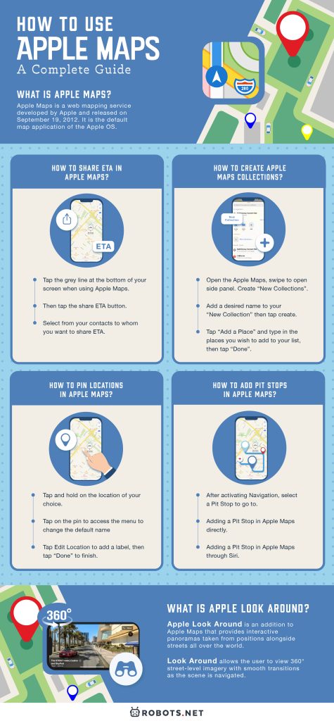
Apple Maps is a web mapping service developed by Apple and released on September 19, 2012. It is the default map application of the Apple OS, replacing Google Maps. The app provides directions, estimated time of arrivals, et cetera. It also features Flyover mode that enables users to explore populated urban centers and other places of interest, all in 3D Landscape.
It’s a good navigation app for all Apple users. However, Apple Maps’ journey to what it is today is far from an easy drive. On its initial launching, the app had some major glitches like misalignment of 3D and 2D images. Because of the unforeseen misperformances, Apple Maps gained painful reviews from critics, with some saying the app is “horrible” and “life-threatening”.
Fast forward to 2020, Apple Maps had some major transformation and is looking better than ever. While it still lags behind competing platforms like Waze and Google Maps, the inclusion of helpful features like transit directions and street-level imagery is no less than an improvement. And with the launch of iOS 14 just sitting in the corner, we can expect the app to get even better.
How Does Apple Maps Works?

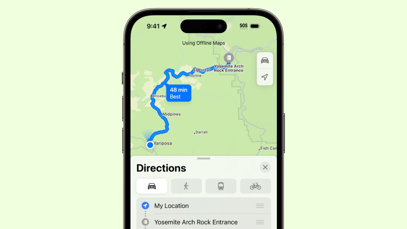
Apple Maps can be used in a variety of ways. The most common is a GPS app that tracks your location and finds the easiest direction to your destination. This is the most common usage of the app, but there are other usages as well.
Key Features of Apple Maps
There are several key features in Apple Maps. One of these is the ability to adjust where you’re going in real-time. An example of which is if you needed to take a detour to go to the market in the middle of your trip. The app allows you to adjust the pathway you’re taking so that you don’t need to wait for that much. You can also send an ETA to the people you’re going to using Apple Maps.
How to share ETA in Apple Maps?
1. Tap the grey line at the bottom of your screen when using Apple Maps.
2. Then tap the share ETA button.
3. Select from your contacts to whom you want to share ETA.
How To Create Apple Maps Collections?
Apple Maps Collections is another new feature introduced in iOS 13. This allows users to search for a list of establishments and locations to visit. It also allows users to create a list of places that can be shared with other people. This feature is helpful if you want to promote places to a friend and family, or if you simply want to create a list of places you want to visit. Here’s how to create a Collection in Apple Maps.
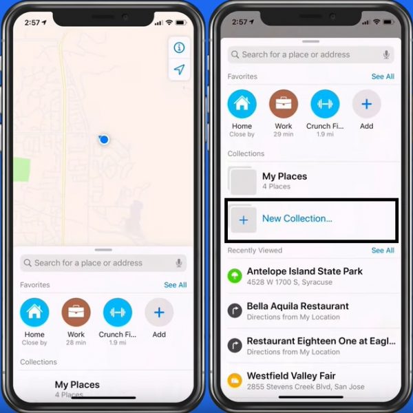
1. Open the Apple Maps application on your device then swipe to open the side panel and create “New Collections”.
2. Add a desired name to your “New Collection” then tap create.
3. Under the Collection you created, tap “Add a Place” and type in the places you wish you want to add to your list.
4. Tap the + sign next to each address to add them to your Collection. Finally, tap “Done” to finish adding places.
How Pin Locations in Apple Maps?
Adding Pins and locations is easy in Apple Maps. All you need to do is tap and hold on the location of your choice. A red pin will then appear. After this, tap on the pin to access the menu to change the default name to the name you desire. Tap Edit Location to add a label to the address you want to pin, then tap “Done” to finish.
Besides this, you can also look for the optimal way to get to said location on the pin. You do this through tap and hold again but look for the Directions button instead. Through this, you can plot the direct way to said destination. This is a useful tool when looking for pathways and other nooks that you need to go to.
How to add Pit Stops in Apple Maps?
Now for something meatier. One thing that must be mentioned is the ability to add Pit Stops on your trips. After all, there will be times that you need to take the loo, eat lunch, et cetera. And having the ability to know the establishments on the road that allow you to do that is helpful in a trip.
Now Apple Maps gives you two ways to do this. And we’ll discuss them both here. Do note though that these won’t work if you didn’t start Navigation and input a target destination. After all, what’s the use if you don’t have a place you need to go to?
So to help that, here are the steps to add Pit Stops in Apple Maps.
1. After activating Navigation, select a Pit Stop to go to
There are a few ways you can add a pit stop to your directions. If you’re not driving yourself or are currently stopped, the first method is probably the best. If not currently driving, you’ll want to use Siri to play it safer.
2A. Adding a Pit Stop in Apple Maps directly
With navigation up and running, swipe up from the bottom and pull up the route card. You’ll see a small button list that includes gas stations, coffee, and eateries. Depending on what time it is, the eateries will be marked by breakfast, lunch, or dinner.
Selecting a category like “Gas Stations” will yield all gas stations along your route. This allows you to choose which one to have a pit stop in. If you’re on a long trip and need a break, you can select either “Dinner” or “Coffee”. Allowing you to pull up a list of restaurants or coffee shops along your route for you to stop at.
Whichever pit stop you decide to make, tap on the green “GO” button next to your selection. Allowing you to automatically add it to your current route.
2B. Adding a Pit Stop in Apple Maps through Siri
You can add a pit stop hands-free with Siri. To do so, say “Hey Siri” to summon your virtual assistant. And say “add” the pit stop of your desires while navigating to your destination. Siri will pull up any relevant stops for you to choose from that are in the direction of your destination.
There are times when you can’t access your phone for safety reasons. If that’s the case, Siri will also ask you to verbally confirm your selection. starting from the top selection downward. So if you don’t want to go to a selection because of preference, say “no”. And Siri will proceed to the next selection. And so on until you find one that suits your taste.
3. Quit the directions to the Pit Stop if you’re finished, or if you need to
If you decide to forgo the stop, tap on the blue “Resume Route” bar on the top of the screen in the app. To remove the stop and continue with your route.
It’s important to note that you can’t command Siri to “resume route”. Telling her to “remove the stop” will kill your planned route entirely. Keep that in mind if you decide to remove a pit stop in the middle of navigation. So if you need to do this, it’s recommended to stop driving to put the instructions by hand.
What is Apple Look Around?

Apple Look Around is an addition to Apple Maps that provides interactive panoramas taken from positions alongside streets all over the world. This feature is helpful when you want to explore a place even before you go. Look Around allows the user to view 360° street-level imagery with smooth transitions as the scene is navigated. The feature was introduced on the iOS 13 update, and ever since, Apple added more features and locales to it.
Look Around is similar to Google Street View. But compared to it, it has less coverage as Google began to do this in 2007, while Apple did it in 2019. There are still some countries that don’t have this feature, however. Apple is still working to physically record other streets to add to its platform.
Apple Maps Connect
Connect is a self-serve local listing portal. Through this, Local businesses now have an opportunity to be found on listings in Apple Maps. Anyone who uses an iPhone, iPad or Mac desktop has access to Apple Maps. So getting listed and appearing to potentially millions of searchers is possible. Apple Maps Connect is a useful tool for business owners. So you should try to take advantage of this.
FAQs
How much Data does Apple Maps use all in all?
Apple Maps uses a remarkably small amount of Phone Data. Usually around 1 MB every 10 minutes. An hour-long trip would lead to 6-7 MB of internet usage. So pretty cheap.
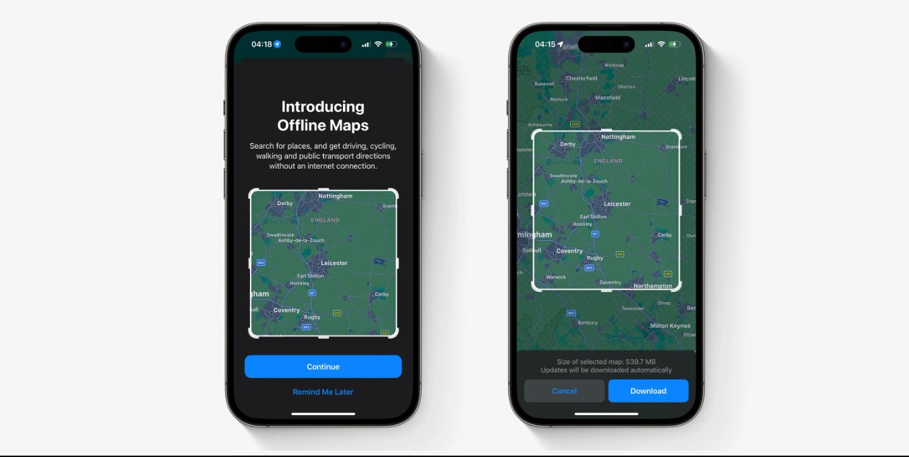
Does Apple Maps have an offline mode?
Unfortunately, Apple Maps does not have any offline mode at all. You can use the navigation option while offline. But you still need to input the destination while online. As the app needs to use data to figure out the best route to your destination.
How to clear Apple Maps History?
To clear your Apple Maps history, tap the search box and proceed to “Favorites”. Below the screen, tap on “Recents” and click the “Clear” button on the upper left corner of your device. If you are signed in to Apple Maps from multiple devices using a single ID, clearing up maps history will permanently delete history from those devices altogether.