Introduction
Welcome to the exciting world of aerial surveys using drones! Drones have revolutionized the way we capture and analyze data, providing us with unprecedented access to aerial views and accurate measurements. Whether you’re a professional surveyor, a researcher, or a hobbyist looking to explore new possibilities, conducting surveys with a drone can open up a world of opportunities.
Surveying with a drone offers numerous advantages over traditional methods. Drones can reach remote or hazardous areas that are difficult to access on foot, allowing for more efficient and cost-effective data collection. They can capture high-resolution imagery and videos, as well as collect precise measurements using advanced sensors such as LiDAR or thermal cameras. The data collected by drones can be used in various industries, including construction, agriculture, environmental monitoring, and urban planning, to name just a few.
However, embarking on a drone survey requires careful planning, technical knowledge, and adherence to regulations. In this guide, we will delve into the key considerations and steps involved in conducting a successful drone survey. From choosing the right drone to post-processing the data, we’ll cover everything you need to know to ensure accurate and reliable results.
Before we dive into the details, it’s important to note that drone surveying falls under the jurisdiction of the Federal Aviation Administration (FAA) in the United States and similar regulatory bodies in other countries. These regulations are in place to ensure safety and responsible drone operation. Understanding and complying with the guidelines is crucial for conducting surveys legally and ethically.
So, whether you’re a beginner or an experienced drone pilot, this guide will provide you with the essential knowledge to conduct surveys with a drone. Let’s get started!
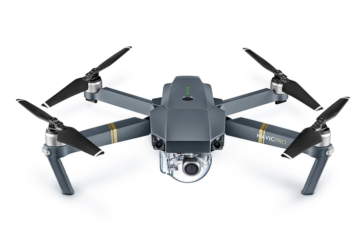
Choosing the Right Drone
The first step in conducting a successful drone survey is choosing the right drone for your specific needs. The drone market offers a wide range of models with varying capabilities, features, and price points. Here are some key factors to consider when selecting a drone:
- Payload Capacity: Determine the payload capacity required for your survey equipment. If you plan to carry a high-resolution camera or additional sensors, ensure that the drone can handle the weight without compromising flight performance.
- Battery Life: Consider the drone’s battery life and flight time. Longer flight times allow for more extensive surveys without the need for frequent battery changes or recharging. Take into account the time needed to cover your survey area adequately.
- Camera Quality: Assess the camera’s resolution, image stabilization capabilities, and the ability to capture necessary data. For surveys requiring high-resolution imagery, look for drones with cameras capable of capturing clear and detailed images consistently.
- GPS and Navigation System: Look for drones equipped with reliable GPS and navigation systems. These features are essential for precise positioning and accurate flight path planning, ensuring optimal data collection.
- Obstacle Avoidance: Consider drones with obstacle avoidance features, such as obstacle detection sensors or collision avoidance technology. These features can help prevent accidents and ensure the safety of the drone during flight, particularly in complex and challenging environments.
- Flight Modes and Intelligent Features: Evaluate the available flight modes and intelligent features that can assist with surveying tasks. Look for features like waypoint navigation, automated flight planning, and target tracking, which can enhance efficiency and reduce human error.
- Durability and Weather Resistance: Assess the drone’s build quality and resistance to environmental conditions. If you plan on conducting surveys in adverse weather or harsh environments, ensure that the drone can withstand such conditions without compromising performance.
- Price and Budget: Determine your budget and consider the cost of the drone, along with any additional accessories or equipment required for your survey. While it’s important to find a drone that meets your needs, it’s equally important to find one that fits within your budget.
Take the time to research and compare different drone models, considering the features that are most important for your specific survey requirements. Reading reviews, seeking recommendations, and consulting experts in the field can also help you make an informed decision.
Choosing the right drone is crucial for the success of your survey. It ensures that you have the necessary capabilities to capture accurate data and perform the required analysis effectively. Now that you understand the key factors to consider, let’s move on to the next section, where we’ll delve into the regulations governing drone surveys.
Understanding FAA Regulations
Before taking your drone to the skies for a survey, it’s essential to understand the regulations set forth by the Federal Aviation Administration (FAA) in the United States. These regulations aim to ensure the safe and responsible operation of drones. Here are some key points to keep in mind:
- Registration: In most cases, drones weighing between 0.55 pounds (250 grams) and 55 pounds (25 kilograms) must be registered with the FAA. This includes recreational and commercial drones. Registration is a straightforward online process that requires the drone owner’s information and a small fee.
- Pilot Certification: If you plan to conduct drone surveys commercially (for financial gain), you may need to obtain a Remote Pilot Certificate. This certification demonstrates your knowledge of FAA regulations and safe drone operation. The certification requires passing an aeronautical knowledge test and background check.
- Flight Restrictions: Drones must be flown within visual line-of-sight (VLOS) of the remote pilot, with a few exceptions. Avoid flying in restricted airspace, such as around airports or government installations, unless you have obtained special permission from the appropriate authorities.
- Height and Distance Limitations: For most drones, the maximum allowable altitude is 400 feet above ground level (AGL). It’s important to adhere to this limit to ensure the safety of other aircraft and respect the privacy of individuals on the ground. Additionally, maintain a safe distance from people, structures, and vehicles to prevent accidents and property damage.
- Flight Plan Submission: In certain controlled airspace or when conducting commercial operations, you may be required to submit a flight plan to the FAA. This helps ensure coordination with other airspace users and allows for the safe integration of your drone into the airspace system.
- Visual Observers and Communication: Depending on the circumstances and airspace requirements, you may need to have a visual observer on the ground to assist with maintaining visual line-of-sight. It’s also crucial to maintain effective communication with the observer and any other personnel involved in the survey.
- Privacy and Data Protection: Respect the privacy of individuals during the survey and ensure that data collected is handled securely and with permission. Be mindful of where and when you capture imagery and follow applicable laws regarding data protection and privacy.
- Insurance: Consider obtaining liability insurance coverage for your drone operation. Insurance helps protect you financially in case of accidents, property damage, or injury caused by the drone during the survey.
It’s important to note that regulations may vary depending on the country or region you are operating in. Familiarize yourself with the specific requirements and guidelines set forth by the respective aviation authorities to ensure legal and responsible drone operation.
Understanding and adhering to these regulations is vital for safe and compliant drone surveys. Failure to comply can result in penalties or legal consequences. By operating within the FAA guidelines, you can conduct your surveys confidently and responsibly.
Now that you have a good understanding of the FAA regulations, let’s move on to the next section, where we’ll discuss the essential steps to prepare for a successful drone survey.
Preparing for the Survey
Proper preparation is key to a successful drone survey. Before you take flight, there are several important steps to follow to ensure a smooth and efficient operation. Here’s what you need to consider during the preparation phase:
- Survey Objective: Clearly define the objective of your survey. Identify the specific data you need to collect, the area you will be surveying, and the desired level of accuracy. This will help guide your planning and ensure that you gather the necessary information to meet your goals.
- Site Assessment: Conduct a thorough assessment of the survey site. Familiarize yourself with the terrain, any potential obstacles or hazards, and nearby structures or power lines that could interfere with the flight. Understanding the site’s characteristics will help you plan the flight path effectively and mitigate possible risks.
- Weather Conditions: Keep a close eye on the weather forecast for the survey day. Ensure that the conditions are suitable for safe and stable drone operation. Avoid flying in strong winds, rain, or fog, as these conditions can negatively affect flight stability and data collection.
- Permission and Landowner Approval: If you are planning to conduct the survey on private property, obtain the necessary permissions from the landowner before flying your drone. Respect the property boundaries and any specific requirements or restrictions the landowner may have.
- Equipment Check: Thoroughly inspect and test your drone and all related equipment before the survey. Ensure that the batteries are fully charged, the propellers are in good condition, and all sensors and cameras are functioning correctly. It’s also essential to have backup batteries, memory cards, and any other necessary accessories on hand.
- Pre-Flight Checklist: Develop a pre-flight checklist to ensure that you don’t overlook any important steps before taking off. Include items such as checking the GPS signal, calibrating the drone’s compass and sensors, confirming software updates, and verifying that all required documents and permits are on hand.
- Safety Measures: Prioritize safety at all times during the survey. Establish a safe area for takeoff and landing, and ensure that bystanders are aware of the presence of the drone. Follow proper emergency procedures and have a plan in place for scenarios such as unexpected malfunctions or flyaways.
- Communication: If you’re conducting the survey as part of a team, establish a clear line of communication with your team members. Ensure that everyone understands their roles and responsibilities and is aware of the flight plan and survey objectives. Effective teamwork and communication are vital for a successful operation.
- Backup and Redundancy: Have contingency plans in place for equipment failures or unforeseen circumstances. Consider having backup drones, batteries, and memory cards readily available. This will help minimize downtime and ensure that you can continue with the survey even if an issue arises.
By following these preparation steps, you’ll maximize the efficiency and safety of your drone survey. Take the time to plan and organize all the necessary elements to ensure a smooth operation. With everything in place, you’re ready to move on to the next section, where we’ll discuss the essential steps for planning the flight path.
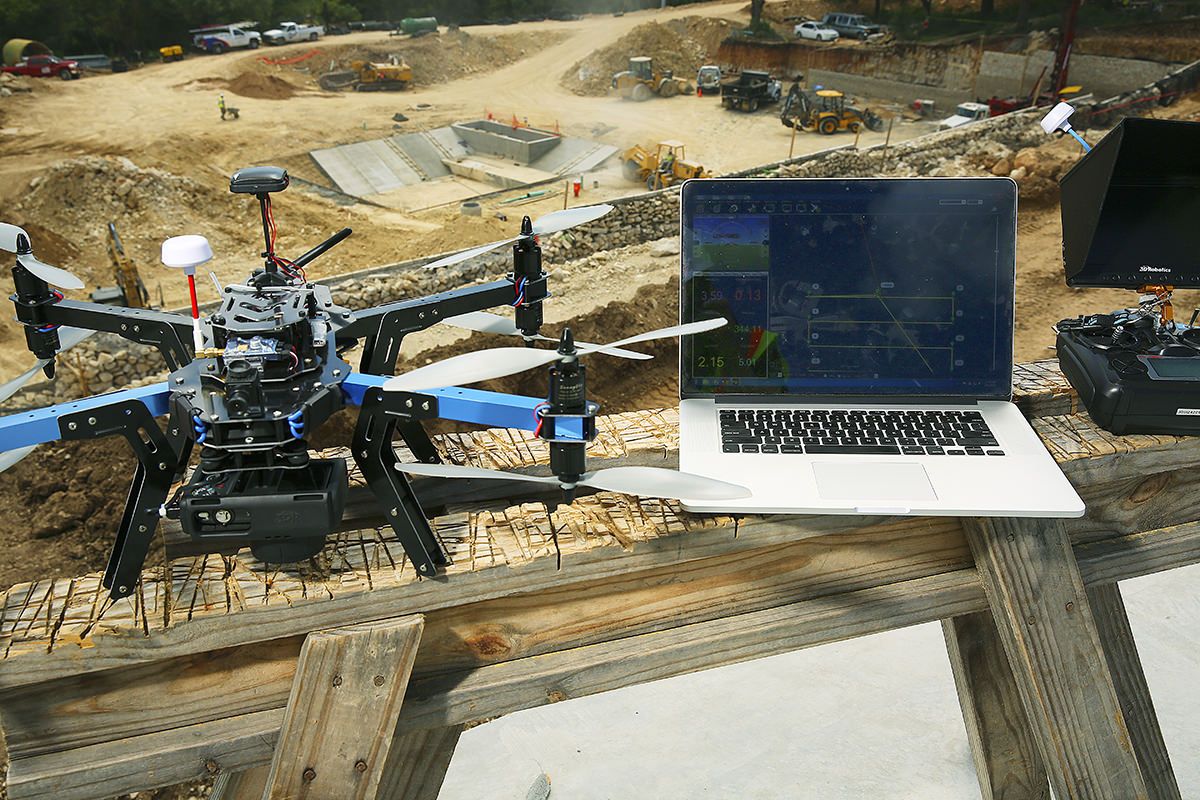
Planning the Flight Path
Planning the flight path is a crucial step in conducting a successful drone survey. A well-designed flight path ensures efficient coverage of the survey area and accurate data collection. Here are the essential steps to plan your flight path:
- Survey Area Mapping: Begin by mapping out the boundaries of the survey area. Use satellite imagery, maps, or ground measurements to accurately define the boundaries. This will help you determine the total area you need to cover and determine the appropriate flight pattern.
- Survey Grid Design: Depending on the survey area’s size and shape, choose an appropriate survey grid design. Commonly used designs include the lawnmower pattern, the zigzag pattern, or the circular pattern. Consider factors such as the resolution requirements, overlapping imagery, and efficiency of data collection when selecting the grid design.
- Ground Control Points (GCPs): Determine if ground control points are necessary for your survey. GCPs are physical markers placed on the ground with accurately known coordinates. They help enhance the geolocation accuracy of the data collected by the drone. If GCPs are required, strategically plan their placement within the survey area.
- Flight Altitude and Overlap: Determine the appropriate flight altitude and overlap for your survey. The flight altitude will depend on the desired ground sampling distance (GSD) and the resolution required for the data collection. The overlap refers to the percentage of overlap between consecutive images to ensure seamless stitching and accurate data analysis.
- Flight Planning Software: Utilize flight planning software to assist in creating the flight path. These software applications provide valuable features such as mission planning tools, real-time flight simulation, and automated waypoint generation. They help optimize the flight path, taking into account terrain, obstacles, and flight parameters.
- Airspace Considerations: Check for any airspace restrictions or temporary flight restrictions (TFRs) in the survey area. Ensure that your planned flight path complies with any airspace regulations and seek any necessary permissions or waivers if required.
- Safety Margins: Incorporate safety margins into your flight path planning. Include extra buffer areas around the survey boundaries to account for wind drift or potential navigation errors. These safety margins help ensure complete coverage of the survey area and prevent any gaps or missed data.
- Flight Path Visualization: Once the flight path is planned, visualize it on the map or in a 3D environment. Use visualization tools to assess the coverage and ensure that the flight path adequately covers the entire survey area. Make adjustments as needed to maximize the data collection efficiency.
- Flight Preparation: Before starting the survey, double-check all flight parameters, waypoints, and mission settings in your drone’s control software. Ensure that you have a clear understanding of the flight plan and any potential challenges or obstacles identified during the planning phase.
By carefully planning your flight path, you’ll maximize the data collection efficiency and accuracy of your drone survey. Consider the survey area’s size, shape, and specific requirements to design a flight path that optimizes coverage and minimizes any potential risks. With the flight path planned, you’re ready to move on to the next section, where we’ll discuss the essential steps for flying the drone during the survey.
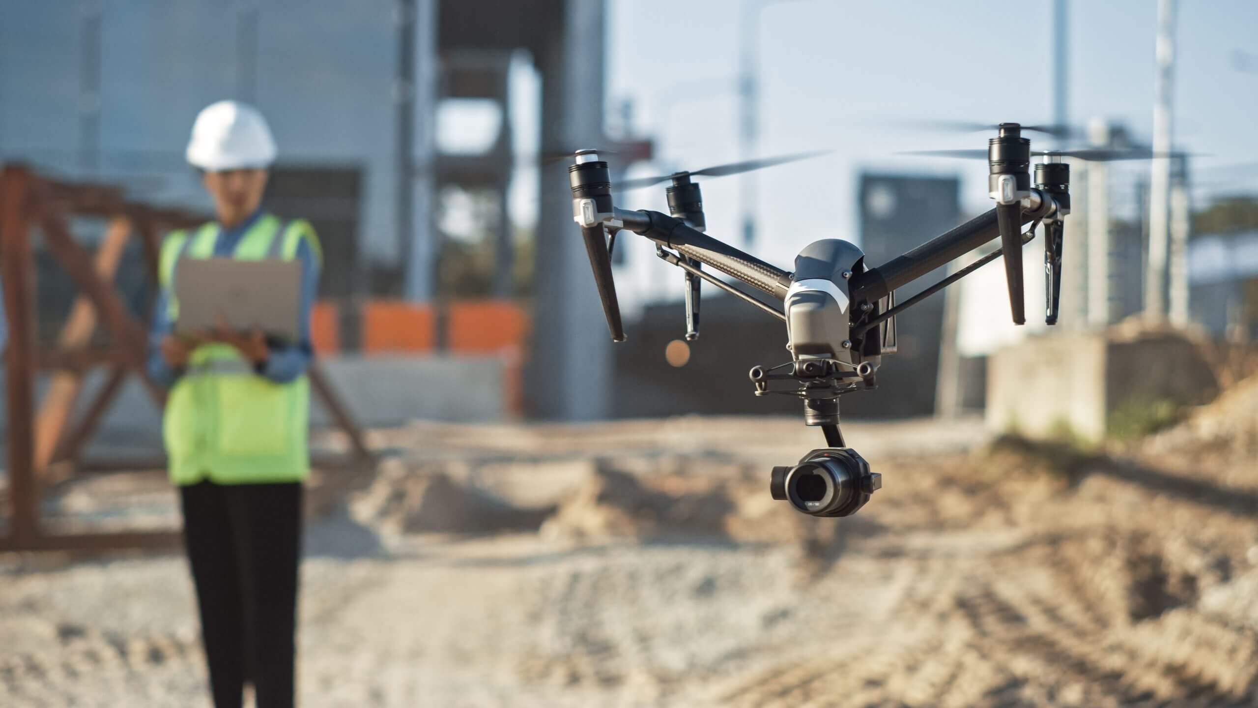
Flying the Drone
Now that you’ve planned your flight path, it’s time to take to the skies and start the drone survey. Flying the drone requires careful attention to detail and adherence to safe operating practices. Here are the essential steps for successfully flying the drone during your survey:
- Pre-Flight Check: Before taking off, perform a thorough pre-flight check of your drone and equipment. Ensure that all components are securely attached, batteries are fully charged, and sensors are calibrated. Double-check that the flight path is programmed correctly in the drone’s control software.
- Clear Takeoff and Landing Area: Select a suitable area for takeoff and landing, ensuring that it is clear of obstacles and obstructions. Be mindful of any bystanders or objects that could interfere with the drone’s flight path. Maintain a safe distance from people, structures, and vehicles during takeoff and landing.
- Monitoring the Drone: Keep a close eye on the drone throughout the flight. Maintain visual line-of-sight (VLOS) as required by regulations and monitor its flight parameters, altitude, and battery levels. Be aware of any changes in weather conditions or obstacles in the flight path and make necessary adjustments.
- Flight Path Execution: Execute the planned flight path by initiating the automated flight mode or manually controlling the drone. Ensure that the drone follows the designated waypoints accurately and captures the necessary data according to the desired parameters (e.g., altitude, overlap, and camera settings).
- Communicating with Visual Observers: If visual observers are present to assist with maintaining VLOS, communicate with them effectively. Provide updates on the drone’s location, altitude, and any potential hazards or obstructions. Establish clear communication protocols before the flight to ensure a smooth and coordinated operation.
- Managing Battery Life: Keep a close eye on the drone’s battery life to ensure a safe and controlled landing. Monitor the remaining battery capacity and plan for a safe return to the landing area before the battery reaches critical levels. Avoid pushing the limits of battery life to prevent unexpected shutdowns during the flight.
- Obstacle Avoidance and Safety Measures: Utilize the obstacle avoidance features of your drone to detect and avoid any potential obstacles or hazards in the flight path. Maintain a safe distance from structures, trees, power lines, and other potential obstructions. Constantly assess the surrounding environment for any changes or potential risks.
- Emergency Procedures: Be prepared for emergency situations and have a plan in place. Familiarize yourself with the emergency procedures provided by the drone manufacturer, such as initiating a return-to-home (RTH) or landing in manual mode. Stay calm and composed in the event of an emergency and prioritize the safety of people and property.
- Flight Log and Documentation: Maintain a record of the flight log and any relevant documentation, including flight times, altitudes, and any noteworthy observations. These records can be valuable for future reference, troubleshooting, or analysis of the survey data.
Remember, safety is paramount during the entire flight. Always prioritize the safety of people, property, and the drone itself. Adhere to the regulations, maintain constant situational awareness, and be prepared for unexpected circumstances. By following these guidelines, you’ll be able to conduct a smooth and successful drone survey.
With the drone successfully flying and capturing the necessary data, the next section will discuss the crucial steps for capturing and analyzing the collected data.
Capturing and Analyzing Data
Once you have completed the flight and collected the necessary data, the next step is to process and analyze the captured information. Proper data capture and analysis are crucial to achieving accurate results and valuable insights from your drone survey. Here’s what you need to consider:
- Data Transfer: Safely transfer the data captured by the drone to your computer or storage device. Follow secure file transfer protocols to ensure the integrity of the data and prevent any loss or corruption.
- Data Organization: Organize the data in a systematic manner, using clear file naming conventions and folder structures. This will help you quickly locate and access specific data sets during the analysis stage.
- Image and Video Inspection: Inspect the captured images and videos to ensure that they are of sufficient quality for analysis. Check for any issues, such as motion blur, lens distortion, or overexposure, that may impact the accuracy and usability of the data.
- Georeferencing: If you used ground control points (GCPs) during the survey, georeference the collected images or point clouds to enhance their spatial accuracy. Use software tools or photogrammetry techniques to align the data with known geographic coordinates.
- Data Alignment and Stitching: If you collected images with overlapping coverage, use image stitching algorithms to align and merge the images into a single, seamless mosaic. This process allows for a complete and accurate representation of the survey area.
- Data Calibration: Calibrate the collected data to correct for any sensor or camera-specific distortions or biases. This step ensures that the data accurately represents the real-world measurements and maintains the required level of accuracy.
- Data Filtering and Processing: Depending on the nature of your survey, apply suitable filters or processing techniques to remove any noise, outliers, or unwanted artifacts from the data. This step helps enhance the quality and reliability of the final results.
- Data Analysis and Extraction: Analyze the processed data to extract meaningful insights. Use specialized software or tools suited to your specific survey objectives. Perform measurements, calculations, and statistical analysis to extract the information needed to meet your project goals.
- Validation and Quality Control: Validate and verify the accuracy and quality of the analyzed data by comparing it with ground truth points or reference data. Use quality control measures to identify and rectify any errors or discrepancies in the data analysis process.
- Reporting and Visualization: Prepare reports or visuals to present your findings effectively. Use graphs, charts, maps, or 3D models to convey the results of your analysis and make it easier for others to understand the insights gained from the drone survey.
Remember, the accuracy and reliability of your analysis depend on proper data capture, processing, and analysis techniques. Consider consulting with experts or utilizing specialized software tools to ensure the highest quality analysis for your specific survey requirements.
With the data captured and analyzed, you are now equipped with valuable information. The next step will focus on post-processing the data to ensure its accuracy and precision.
Post-Processing the Data
Post-processing the data is an essential step in ensuring the accuracy and precision of the information collected during your drone survey. This phase involves refining and refining the raw data into a usable format for analysis and decision-making. Here’s what you need to consider when post-processing your drone data:
- Data Backup: Before performing any post-processing tasks, make sure to create a backup of the raw data. This ensures that you have a copy of the original data in case any issues or errors arise during the post-processing stage.
- Data Conversion: Depending on the type of data collected (such as images, videos, or point clouds), you may need to convert the data into a compatible format for analysis and visualization. Use appropriate software or tools to convert the data as required.
- Data Filtering and Cleaning: Clean the data by removing any noise, outliers, or artifacts that may have been introduced during the data collection process. Use filters or algorithms to eliminate unwanted elements and enhance the quality of the data for further analysis.
- Georeferencing and Coordinate Systems: If geolocation accuracy is essential, georeference the data by linking it to known reference points or coordinates. Ensure that the collected data aligns with the correct coordinate system, allowing for accurate spatial analysis and integration with other datasets.
- Feature Extraction: Extract relevant features or attributes from the data to enable further analysis and interpretation. This could include identifying objects of interest, measuring distances, calculating volumes, or detecting patterns or changes over time.
- Integration with Other Data Sources: Integrate the drone data with other datasets or relevant information sources to gain a comprehensive understanding of the survey area. This could involve combining drone imagery with GIS data, satellite images, or existing maps to provide a more in-depth analysis.
- Data Visualization: Visualize the processed data using graphical representations, maps, or 3D models. Visualization techniques help convey the results to stakeholders and facilitate a better understanding of the surveyed area. Choose appropriate visualization methods based on your survey objectives and target audience.
- Data Accuracy Assessment: Assess the accuracy of the processed data by comparing it with ground truth data or known measurements. Conduct a validation process to ensure the data’s reliability and identify any potential errors or discrepancies that may have occurred during post-processing.
- Documentation and Reporting: Maintain thorough documentation of the post-processing steps and parameters used. Create detailed reports or summaries that outline the methods, processing techniques, and final results obtained from the drone survey. These documents will serve as a reference and aid in future analysis or decision-making processes.
Post-processing the data is a critical step in transforming raw drone data into valuable information. By applying appropriate filters, cleaning techniques, and analysis methods, you can refine the data to meet your specific objectives and deliver reliable results. Keep in mind that the post-processing steps will vary depending on the type of data collected and the goals of your survey.
With the data successfully post-processed, you can move forward to the crucial step of ensuring the accuracy and precision of the survey results. The next section will explore techniques for overcoming challenges during the drone survey process.
Ensuring Accuracy and Precision
Ensuring accuracy and precision is paramount in drone surveys to obtain reliable and valuable results. By implementing appropriate techniques and following best practices, you can enhance the quality of your data and maintain a high level of accuracy throughout the survey process. Here are some key considerations:
- Calibration and Ground Truthing: Calibrate your drone and survey equipment to ensure accurate measurements. Perform regular checks and calibration procedures to correct any sensor biases or inaccuracies. Validate your data by comparing it against ground truth points collected through traditional surveying methods or trusted reference sources.
- Ground Control Points (GCPs): Place GCPs strategically within the survey area to provide precise geolocation references for the aerial data. Use accurately surveyed and established points to calibrate and align the collected data, improving its accuracy and spatial consistency.
- Data Overlap and Redundancy: Ensure sufficient overlap in the collected images or point clouds to facilitate accurate image stitching and point cloud reconstruction. Overlap allows for more reliable feature matching and improves the accuracy of 3D models or orthomosaic generation.
- Quality Control Measures: Implement strict quality control measures throughout all stages of the survey process. Regularly check and validate the integrity of the collected data, review aerial imagery for sharpness and clarity, and conduct statistical analysis to identify any outliers or irregularities that may impact the accuracy and precision of the data.
- Survey Technique Optimization: Continuously refine your survey techniques to optimize accuracy and precision. Evaluate and fine-tune flight parameters, camera settings, and data collection methods based on the survey requirements and the desired level of accuracy. Experiment with different configurations and analyze the results to identify the most effective approaches.
- Data Processing Validation: Validate the accuracy of the post-processed data by performing quality checks and comparisons. Use them to verify against known measurements, ground truth points, or external data sources. Pay close attention to the results of your analysis and identify any issues or discrepancies that may require further investigation.
- Continuous Training and Education: Stay updated with the latest advancements in drone technology and surveying techniques. Keep up-to-date with industry best practices and participate in professional training and development opportunities. Continuous learning will enhance your understanding of the factors influencing accuracy and precision, allowing you to improve your survey outcomes.
By implementing these measures, you can improve the accuracy and precision of your drone surveys and generate reliable and trustworthy results. It’s important to remember that accuracy and precision are cumulative efforts that encompass all stages of the survey process – from data collection to post-processing and analysis.
Overcoming Challenges
Although drone surveys offer immense benefits, they can come with challenges that need to be addressed to ensure accurate and precise results:
Overcoming Challenges
Drone surveys offer numerous advantages, but they also come with their fair share of challenges. Recognizing and addressing these challenges is essential for conducting successful surveys. Here are some common challenges and strategies to overcome them:
- Weather Conditions: Adverse weather conditions like strong winds, rain, or fog can affect drone stability and data quality. Monitor weather forecasts and plan your surveys during favorable conditions. Consider rescheduling or using alternative survey methods if the weather poses a significant risk.
- Regulatory Compliance: Compliance with aviation regulations and obtaining the required permits can be complex and time-consuming. Stay well-informed about the regulations in your area and ensure proper documentation and certification for commercial operations. Plan ahead and allow sufficient time for obtaining necessary approvals.
- Data Processing Challenges: Processing large amounts of data collected during drone surveys can be daunting. Ensure that you have sufficient hardware capabilities and powerful software tools for efficient data processing. Consider cloud-based solutions or outsourcing to specialized service providers to handle massive datasets and complex analyses.
- Sensor Limitations: The accuracy and quality of the data collected is dependent on the capabilities of the sensors onboard the drone. Assess the limitations of the sensors you are using, such as resolution, range, or sensitivity, and make informed decisions regarding their suitability for your survey objectives.
- Obstacle Avoidance: Navigating around obstacles such as trees, buildings, or power lines requires careful planning and execution. Use obstacle avoidance features of your drone or manually map out clear flight paths to mitigate the risk of collisions. Conduct thorough site assessments before the survey to identify potential obstacles and plan accordingly.
- Crew Coordination: Working as a team during drone surveys requires effective communication and coordination. Clearly define roles and responsibilities, establish communication protocols, and conduct regular briefings to ensure everyone is on the same page. Practice and train for emergency scenarios to be prepared for unforeseen challenges.
- Data Privacy and Security: Protecting the privacy of individuals, as well as the security of the captured data, is of utmost importance. Adhere to privacy regulations, obtain necessary permissions, and handle data securely. Implement encryption, user access controls, and secure data storage practices to mitigate potential risks.
- Environmental Conditions: Unpredictable factors like changing lighting conditions, uneven terrain, or varying vegetation can impact data collection and analysis. Conduct multiple surveys under different conditions to account for variations and ensure robust data acquisition. Adjust settings and capture techniques accordingly to optimize data quality in challenging environments.
- Data Interpretation: Extracting meaningful insights from the collected data requires expertise and domain knowledge. Leverage the expertise of professionals in fields such as surveying, GIS, or data analysis to interpret the data accurately. Use advanced analytical techniques, visualization tools, and statistical analysis to uncover patterns, trends, and relationships within the data.
By proactively addressing these challenges, you can overcome obstacles and maximize the potential of your drone surveys. Develop contingency plans, seek assistance when needed, and stay flexible in adapting to changing circumstances. With perseverance and careful planning, you can navigate through challenges and achieve successful outcomes.
Now that we’ve explored ways to overcome challenges, it’s time to wrap up this guide with a summary and final thoughts on conducting drone surveys.
Conclusion
Drone surveys offer immense potential for capturing accurate and detailed data from aerial perspectives. They have transformed the way we conduct surveys, providing us with efficient, cost-effective, and versatile tools for various applications. By following the key steps and considerations outlined in this guide, you can conduct successful drone surveys and obtain valuable insights.
Choosing the right drone, understanding and adhering to FAA regulations, careful preparation, flight path planning, precise data capture, and accurate analysis are essential for achieving reliable results. Overcoming challenges such as weather conditions, regulatory compliance, data processing, and obstacle avoidance is crucial for successful survey operations. Ensuring accuracy and precision, along with continuous training and education, further enhances the quality of your drone surveys.
Remember, safety should be the top priority throughout the entire survey process. Always prioritize the safety of people, property, and the drone itself. Stay informed about airspace regulations, obtain necessary permissions, and operate within the guidelines set by regulatory authorities.
Drone surveys continue to evolve with advancements in drone technology and data analysis tools. Stay up to date with the latest developments and continuously refine your survey techniques. Seek opportunities for professional development and learning to enhance your skills and capabilities in conducting drone surveys.
With the right knowledge, skills, and careful planning, you can unlock the full potential of drone surveys. Embrace this innovative technology, leverage its benefits, and explore the limitless possibilities it offers in various industries and fields of study. Conduct your drone surveys responsibly and ethically, respecting privacy laws and data protection regulations.
Now, armed with the insights from this guide, it’s time to take flight and embark on your own drone survey adventures. Happy surveying!