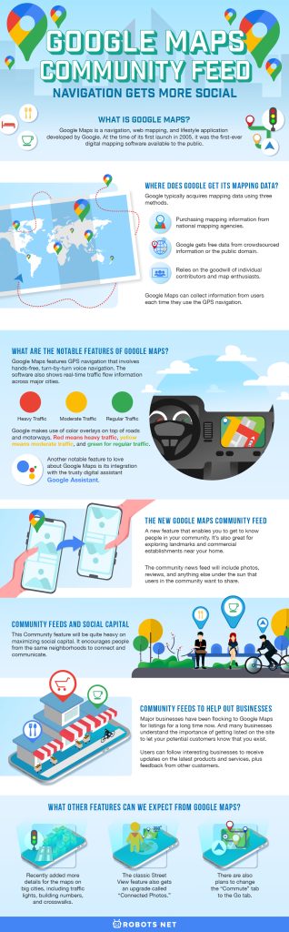
Google Maps is getting an upgrade from the Google community, and it will include some social-media type features. Front and center is the feature aptly named Community Feed. This new feature will provide users with lots of information, including local reviews, photos, recommendations, updates, and ratings from ordinary users and experts alike. Intended to function much like social media, the feed will help you get to know your neighborhood better.

What Is Google Maps?
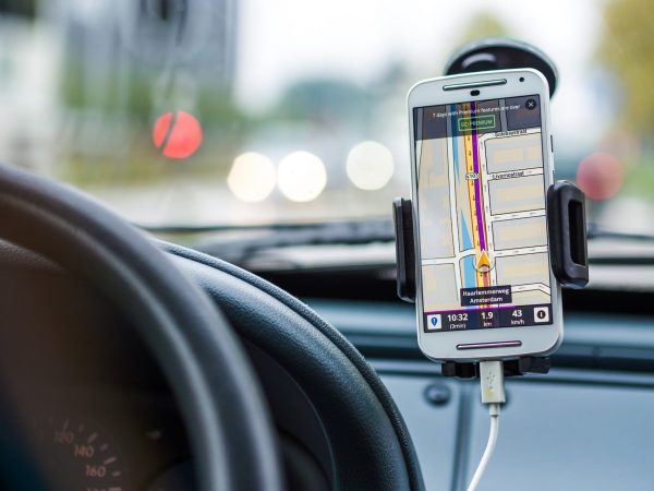
Google Maps is a navigation, web mapping, and lifestyle application developed by Google. At the time of its first launch in 2005, it was the first-ever digital mapping software available to the public. It also contained the rudimentary features of a world map. Eventually, it became hailed by GlobalWebIndex as one of the most popular apps in 2013, with more than half of global smartphone users having used it at least once.
Google Maps has since expanded its map offerings to include different modes of viewing cities and locations worldwide. We can divide these modes into four: the satellite view, earth view, street view, and the default roadmap format. Google Maps can also now give you information on traffic details, public transport lines, cycle-friendly routes, and nearby places.
The app’s reporting system relies on satellite data and algorithms, which means you need to be connected to the internet to fully utilize Google Maps. But if you’re the type who loves the outdoors and navigates using your smartphone, you can still make use of the Google Maps app’s offline map feature.
Also check out this helpful beginners’ guide about Maps.me Offline.
Where Does Google Get Its Mapping Data?

Google Maps is arguably the most comprehensive map, boasting the largest collection of satellite imagery available. The software houses over two million consolidated maps of places worldwide divided into many geographic areas.
We can hardly contest the amount of work that Google put into building these maps. But then again, there’s the old-time question of where exactly Google gets all of its data. The answer is simpler and much less exciting than we thought. Google typically acquires mapping data using three methods.
The first involves purchasing mapping information from national mapping agencies. Second, Google also gets free data from crowdsourced information or the public domain. Lastly, Google also relies on the goodwill of individual contributors and map enthusiasts. These contributors usually edit the in-app Map Maker for free. Google Maps can collect information from users each time they use the GPS navigation.
Check out this article to know more about the most intriguing and informative hidden gems on Google Maps.
What Are the Notable Features of Google Maps?
Google Maps features GPS navigation that involves hands-free, turn-by-turn voice navigation. This feature allows users to set a destination, and it will generate a route recommendation that you can follow in real time. The software also shows real-time traffic flow information across major cities.
To enhance ease of use, Google makes use of color overlays on top of roads and motorways. Red means heavy traffic, yellow means moderate traffic, and green for regular traffic. The software also offers various routing modes for cars, buses, trucks, pedestrians, and bicycles. It provides custom-fit information (e.g., bike lanes for when you’re on a bike or highways for when you’re driving).
Another notable feature to love about Google Maps is its integration with the trusty digital assistant, Google Assistant, which is an excellent competitor to Alexa and Siri. Google Assistant can take on voice commands and is also integrated with Google Maps, so you can take it on the road with you to get things done while you drive. You can ask Google Assistant questions about traffic or routes as you drive. You can also ask it to search the internet, schedule appointments, or take hands-free calls. Unfortunately, Google has limited its availability for motorcycle and driving modes only.
There are other notable features on Google Maps other than AI-assisted driving. The software also allows users to conduct customized restaurant searches, create personalized maps, and view panoramic photos of famous places. For more useful features, check out this list of the best hidden features of Google Maps.
The New Google Maps Community Feed

Google Maps Community Feed is a new feature that enables you to get to know people in your community. It’s also great for exploring landmarks and commercial establishments near your home. Aptly named so, this feature actually reminds us of the Community pages on Facebook. It takes on a more social touch with user recommendations posted on the community feed. Google has conveniently placed the feed right under the “Explore” tab.
The community news feed will include photos, reviews, and anything else under the sun that users in the community want to share. That includes recent events and newly opened restaurants. There are also new products to try out and recommended establishments.
You might notice almost immediately that this newest feature has been inspired largely by social media sites like Instagram, Facebook, and Pinterest. The feature lets you post photos and videos of your delicious lunch or recent holiday with your family. For each photo or video, you can write a description of the event or experience. You can also write full-blown reviews about any experience that you want. That is, for as long as the content doesn’t disobey community standards, of course.
True to the Google Maps tradition of individualized search results and restaurant suggestions, this new feature also allows you to set your preferences. This will help you align the feed’s recommendations with your interests. Google encourages users to fill in food preferences, dietary restrictions, and places of interest. This will help generate feeds that fit your style. For example, if you’ve marked interest in Japanese cuisine, the software will show you recommendations related to such.
Community Feeds and Social Capital

This Community feature will be quite heavy on maximizing social capital. It encourages people from the same neighborhoods to connect and communicate. We’re quite sure that other social media software has already tried the neighborhood proximity angle when getting people to socialize. And many of these neighborhood-focused social media have turned out to be quite successful at bringing communities together. People have also sometimes relied on these community pages to report serious crimes.
In other instances, it is useful for selling items or entire houses. We’re not sure if Google is aiming for a TripAdvisor feel to this new feature. But it definitely feels that way from the outset. We can already envision people posting a picture of their favorite dishes from their favorite restaurants or concerts that they’ve gone to. We also expect discussions about the best hotels and restaurants from community members.
Community Feeds to Help Out Businesses

It’s also quite clear that Google plans to populate each location with as much information as possible. And this is the perfect opportunity for businesses to make themselves known without being too intrusive or annoying. Major businesses have been flocking to Google Maps for listings for a long time now. And many businesses understand the importance of getting listed on the site to let your potential customers know that you exist. We might even go so far as to say that businesses that aren’t visible on Google Maps don’t exist in the eyes of the public. The community feeds are also the perfect place for businesses to provide additional information like delivery options and updated online services. Users can follow interesting businesses to receive updates on the latest products and services, plus feedback from other customers.
Google also wants to make sure that its new feature gets a warm public reception. As such, they are doing the public some good old-fashioned public service. They are planning to include safety precautions at the restaurants and public places you’re planning to visit. They’re also planning to add Covid-19 statistics per city, but we’re not sure when that feature will roll out.
The new Google community feature will be a server-side update, which means you will no longer need to re-install Google Maps on your device to experience it. The software update should automatically reflect in your app if you have Google Maps already installed on your phone.
What Other Features Can We Expect From Google Maps?

Google recently added more details for the maps on big cities, including traffic lights, building numbers, and crosswalks. Google added these details to some of the largest and most popular cities in the world. For example, if you zoom all the way in on places like Tokyo, Japan, you will see some striped crosswalks and building numbers for a more detailed view of each street.
There are also plans to change the “Commute” tab to the Go tab, which would serve as a general bookmark section other than locations to and from your work or home. The software will also use traffic algorithms to generate suggestions on the fastest or shortest routes to your destination, depending on which one you prefer.
The classic Street View feature also gets an upgrade called “Connected Photos.” People who are familiar with Street View footage know that these images have 360-degree navigability. With standard Street View footage, you can navigate backward and look to the left and right while traversing a street online. Google usually employs specialized Google cars with special camera equipment on top, so very rarely do ordinary citizens get to contribute their own Street View footages.
With Connected Photos, users can simply open the Street View app and walk on the street while the software automatically captures images that you can later navigate in Street View. However, we need to note that aspiring contributors will still need a device compatible with the specifications of the software. It would take an AR Core-compatible phone with Google’s 3D-sensing Augmented Reality framework to make this work. However, it must be noted that playback for footage captured using Connected Photos only allows backward and forwards movement instead of the regular sideways.
Final Thoughts on Google Maps Community Feed

The Google community has always relied on Google Maps for navigational purposes. But now, you can also rely on the software to get feedback from communities about specific places and experiences. The new community features won’t interest everyone, but it might just work in bringing communities together, at least digitally.
A part of us also wishes that the community feature was more original than its current form. Maybe Google could have a unique platform if they wanted to make this feature stand out from all the social media websites. We’re eager to see if Google Maps will manage to pull off its social media aspirations with this new Community feed. And if you’ve never been a fan of Google Maps as a navigation tool, not to worry because there are other navigation apps to help you navigate digitally.