




Pull up a flight tracking app on any given afternoon and the map looks almost alive. Hundreds of aircraft icons crawl across continents, arc over oceans, and cluster around busy airports. Each one is a real flight carrying real passengers, heading somewhere specific. The app knows the altitude, the speed, and the heading. It refreshes every few seconds without you touching a thing. That kind of real-time awareness used to belong exclusively to air traffic controllers. Now it fits in your pocket, free of charge, and tens of millions of people reach for it every week.
Signal Check
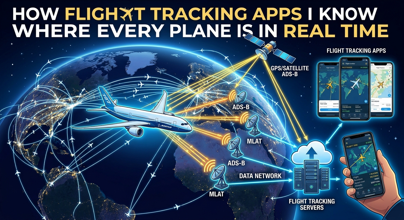
Flight tracking apps draw their real-time accuracy from a combination of aircraft-broadcast radio signals, a crowd-sourced global receiver network, and live data feeds from aviation authorities.
- Most commercial aircraft broadcast their GPS position, speed, and altitude every second using a standard called ADS-B.
- Apps like Flightradar24 and FlightAware tap into thousands of volunteer-owned ground receivers spread across dozens of countries.
- Coverage over oceans is improving rapidly as satellite-based ADS-B reception fills in where ground receivers cannot reach.
Why So Many People Track Flights They Are Not Even On
The appeal of flight tracking stretches far beyond nervous flyers watching a delayed connection. Travelers use these apps to confirm whether the inbound aircraft on their next flight has actually left its origin city. Airlines are notoriously slow to post honest updates. A glance at a tracking app can tell you in seconds that the plane is still sitting on the tarmac two states away. When a connection is tight, that information changes decisions in a way that a vague gate announcement never could.
Families timing airport pickups have turned these apps into a household ritual. Rather than arriving forty minutes early and circling the arrivals curb, they watch the flight descend, touch down, and taxi toward the gate before they even leave home. The tracking apps are simply more accurate than airline-provided status pages, which often lag by ten to fifteen minutes or update in unhelpful bursts.
Aviation enthusiasts make up a passionate segment of the user base, tracking rare aircraft types, following specific tail numbers across continents, or watching how airports sequence arrivals during a weather system. Journalists covering aviation disruptions have found these tools indispensable for documenting ground stops, mass diversions, and cancellations with timestamped, verifiable precision that airline press releases do not provide. The apps created a form of transparency the industry never intended to offer, and cannot walk back.
The Constant Radio Signal Every Commercial Aircraft Sends
Most modern commercial aircraft carry equipment that broadcasts a continuous radio signal containing the aircraft's GPS-calculated position, altitude, speed, heading, vertical rate, and a unique identifier tied to that specific airframe. This happens automatically, roughly once per second, without any crew input required. The signal travels outward in all directions on a dedicated radio frequency. Any receiver with compatible hardware, whether operated by an air traffic authority or a hobbyist, can pick it up and decode what it contains.
The technology making this possible is ADS-B technology, short for Automatic Dependent Surveillance-Broadcast. It was designed to replace older secondary radar systems that required expensive ground equipment to actively interrogate passing aircraft. ADS-B flips that model: the aircraft uses its own GPS to calculate position and broadcasts that data outward continuously. Ground stations, satellites, and home antennas simply listen. If you want a fuller picture of how the broadcast standard works before moving on, the link above covers the mechanics without requiring an avionics background.
Regulators recognized the advantages early and applied pressure across the industry. The result is a global fleet of commercial aircraft that are, almost universally, transmitting their positions at all times. That regulatory alignment is why flight tracking apps can show flights from dozens of countries on the same map, all decoded from the same underlying signal format.
The Global Network Built by People With Antennas on Their Rooftops
Flight tracking companies do not own the receiver infrastructure that covers most of the world. They built something more creative: a community of contributors who run small home receivers, upload the data they capture, and keep the network dense and accurate in exchange for upgraded app access. It is a genuinely clever arrangement that scaled faster than any proprietary hardware rollout could have managed.
A home ADS-B receiver setup is inexpensive to put together. A USB software-defined radio dongle, a compact antenna, and a low-cost single-board computer are all that is needed. The antenna mounts near a window or on a rooftop. The software decodes incoming ADS-B signals from aircraft overhead in real time, streaming the data to the tracking platform's servers. The whole setup runs passively after the initial configuration, requiring almost no ongoing attention.
The density this creates over populated areas is striking. Over central Europe and the northeastern United States, a single aircraft may be picked up simultaneously by thirty or forty independent receivers. That redundancy lets the platform cross-check position reports, smooth flight traces, and handle brief signal gaps without losing continuity on a flight's track. The more receivers in a given area, the crisper and more reliable the picture becomes. It is a distributed infrastructure held together by curiosity and a shared interest in the sky.
What the App Shows You When You Tap a Flight
Tap any aircraft icon and the information that appears is more complete than most people expect. The flight number, operating airline, aircraft type, and specific registered tail number are typically all present. Below that sits the departure airport, the arrival airport, the scheduled times, the actual departure time, and a continuously updated arrival estimate based on how the flight is currently progressing.
Live data includes altitude in feet, ground speed in knots or kilometers per hour, and vertical speed showing whether the plane is climbing or descending and at what rate. The trail behind the aircraft shows the exact path flown since takeoff. The projected line ahead reflects the filed flight plan route. Some platforms layer in live weather data, turbulence forecasts, and airspace boundaries on the same map, giving a genuinely complete picture of the environment around the flight.
The schedule and gate information that appears alongside tracking data does not come from ADS-B signals. It comes from direct data partnerships with airlines and airport systems. When a flight lands, the app draws the official block-in time from the airline's own records rather than estimating it from the position trace. Delay codes and gate assignment changes feed through the same channel. That layering of sources is what makes the apps feel unusually authoritative compared to official airline communications.
How Different Data Layers Feed the Same Map
| Data Source | What It Provides | Coverage Area |
|---|---|---|
| ADS-B ground receivers | Live position, speed, altitude, aircraft ID | Land areas with volunteer receiver networks |
| Satellite ADS-B | Same position data captured from orbit | Oceans and remote regions without ground infrastructure |
| Airline and airport data feeds | Schedules, gate assignments, delay codes, block times | All commercial flights worldwide |
| Government radar data | Secondary position tracking for validation | United States, Europe, select regions |
Where the Coverage Still Has Limits
Ground receivers have one fundamental constraint: they need to be on the ground, within range of the aircraft. Over open ocean, there are no receivers for hundreds or thousands of miles. Until recently, aircraft crossing the North Atlantic or the Pacific simply vanished from consumer tracking apps once they passed out of land-based receiver range. They reappeared only as they approached the destination continent, picking up signal from coastal stations.
Satellite-based ADS-B reception has changed that picture substantially. Low-earth orbit satellites can receive ADS-B signals from aircraft below them and relay that data to ground systems within seconds. Coverage over major oceanic routes has improved to the point where most transatlantic flights now appear continuously on the major tracking platforms. The update rate over water is slightly slower than over densely covered land areas, but the gap between the two is narrowing each year as satellite constellations expand.
Some aircraft do not appear at all, by design. Military flights typically operate without transmitting the civilian ADS-B signals that consumer tracking apps can read. Private and business aircraft can request to have their registrations excluded from public tracking databases through opt-out programs run by aviation regulators. The U.S. Federal Aviation Administration administers one such program under its broader ADS-B compliance rules for civil aviation. An operator can request their tail number be withheld from real-time public feeds, which is why certain high-profile private jets appear as unidentified callsigns or drop off the map entirely. Ground-level radio interference can degrade signal quality in congested urban areas, though the redundancy of multiple overlapping receivers typically compensates. Regions without strong volunteer networks, particularly parts of central Africa and interior South America, still have thinner coverage, though satellite reception continues to fill those gaps gradually.
The Hidden Infrastructure Behind Every Flight You Have Ever Tracked
Flight tracking apps look simple: a map, a cluster of icons, a handful of numbers. The infrastructure underneath is anything but simple. Every moving icon on the screen represents an aircraft with an ADS-B transmitter firing roughly once per second. That signal travels at the speed of light to one or more receivers, possibly including a unit run by a retired engineer in a suburb somewhere. The receiver decodes the signal and uploads the data over a standard home internet connection. Servers collect that upload alongside dozens of reports from other nearby receivers, cross-check the data, smooth the position trace, and render the result on your screen. The whole sequence takes a few seconds.
Layer on top of that the airline data feeds carrying schedule and gate information, the government radar inputs adding secondary position validation, and the satellite receivers filling in over oceans, and the result is a remarkably complete picture of global air traffic, assembled from sources that span government regulators to hobbyists with antennas mounted above their gutters.
For the average person, the practical value is straightforward. These apps give travelers information that airlines and airports have historically kept opaque or released on their own slow schedule. You can see whether your inbound aircraft is airborne before the gate agent makes an announcement. You can watch a family member's flight from takeoff to touchdown without calling anyone. You can satisfy a genuine curiosity about the crowded sky above your city at two in the morning. None of that required building a new industry from scratch. It required a broadcast standard, a radio receiver the size of a thumb drive, and a few thousand people who thought tracking planes sounded like a good use of a Sunday afternoon.